We explore what an extreme future has in store for the region’s crops and speak to local farmers who are harvesting hope through nature-based practices.
Bright or blight? The Potomac River’s harvests face an uncertain future in a warming world
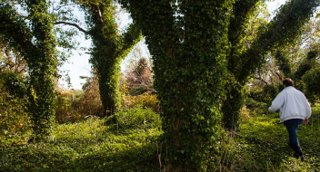
The streams and fertile lands of the Potomac River are the lifeline of our community, providing us with the water we drink and supporting the local harvests that feed our families and drive our region’s economy.
Indeed, fishing and agriculture play a significant role in our livelihoods and how we think about the unique and special qualities of our community.
The farmers who cultivate local lands and fisherfolk who harvest the Potomac’s waters are intimately connected with our natural world and have seen it change – for better and worse – over the years. For decades now, they have witnessed the impacts the climate crisis is having on their crops and operations.
In this penultimate section of our local climate series, we’ll explore what a hotter, more extreme future has in store for the region’s crops and answer these questions:
Can crabbing and local fisheries overcome pollution and the climate crisis?
Will changes to the climate produce bumper or bummer crops in the future?
What farming practices are contributing to pollution and climate change?
Can we farm in a way that meets community needs, supports family farms, and helps the environment?
Let’s dive into the latest climate research and hear from local farmers!
Can crabbing and local fisheries overcome pollution and the climate crisis?
An iconic symbol of the Chesapeake Bay, the blue crab is a staple of our local economy, environment, and food culture. Found on coffee cups, bumper stickers, license plates, and menus, the clawed critter is part of our cultural identity and a driver of efforts to restore clean, safe waters to the Bay and its tributaries, the Potomac River included.
Since the early nineteenth century, crabbing has provided stable livelihoods for thousands of families in the Chesapeake Bay area, including Haley Decatur’s family. Haley, now in her twenties, grew up on the banks of the Potomac River in a small town called Widewater in Stafford County, Virginia.
My family has been crabbing on the Potomac River since the late 1800s. Back then, there wasn’t any other source of income on the Widewater Peninsula – you either farmed, made liquor, or crabbed and fished. Some of my earliest memories consist of early mornings, watching the sunrise from the floor of my father’s crab boat, wrapped up in the comforter from my bed.”
Haley Decatur Lifelong Potomac River Crabber
Despite progress, local fisheries continue to face threats from water pollution
After decades of neglect, the Potomac River is making a comeback. Findings from Potomac Conservancy’s 2020 Potomac River Report Card confirm that several health indicators are trending in a positive direction.
With the notable exception of urban polluted runoff, major sources of pollution have declined enough to allow underwater grasses to rebound and support growing populations of shad, white perch and other indigenous fish.
And yet, local crab and oyster fisheries are not in the clear as pollution levels remain too high to fully support a thriving underwater ecosystem. The climate crisis is only making matters worse as increasing polluted runoff and warming waters bring new challenges to restoring the Potomac River to full health.
Learn more about fish and vulnerable river habitats.
Climate change is projected to disrupt the region’s blue crab population.
Driven by climate change, warming waters and changes in the salinity levels are expected to disrupt the region’s blue crab population.
Warming waters
As a result of atmospheric heating, surface temperatures in the Chesapeake Bay and Potomac River have been rising at an average rate of 1.2℉ per decade since 1985 according to the University of Maryland’s Center for Environmental Science.
Warm water holds less dissolved oxygen than cooler water, creating dead zones and harmful conditions for fish and aquatic species that depend on healthy oxygen levels to survive.
As the climate warms, our region is experiencing more frequent and extreme storms over time. In turn, intensifying rainfall is shifting the salinity zones in the Potomac, a tidal river, and affecting commercial fishing.
Crabbing in the Potomac is becoming harder as local crabber Haley explains, “When working on a boat, the working conditions are heavily reliant on the weather. The more rainfall we get, the fresher the water becomes, disrupting the salinity that the crabs prefer. This keeps the crabs south longer, in saltier water, before they migrate up north into the Potomac River,” adding, “Everything is 30 to 40 days behind due to climate change and human disturbance.”
The Potomac River needs our help. Working on the water has really forced me to implement a sustainable way of living in my own life. I am pretty passionate about taking care of our environment, but I truly think we need to step up our efforts.
Will changes to the climate produce bumper or bummer crops? It’s a mixed bag.
As stewards of the land, farmers know intimately how weather patterns and long-term climate trends alter the terrain and impact their livelihoods.
The effects of climate change can be both beneficial and harmful for local farming. Seasonal changes are lengthening growing seasons but increasing water and heat stress may negate potential benefits and threaten the region’s food security.
3 climate threats to our local crops
Carbon Dioxide
Carbon dioxide (CO2) is an essential ingredient for photosynthesis, a process by which plants turn sunlight into oxygen and glucose for growth. An increase in carbon dioxide (CO2) may be beneficial for some crops, but also for invasive weeds.
Wheat, barley, and other cold-season grains respond well to increased CO2 levels and could see 10-20% higher yields in the next century based on current projections.
However, a study in Baltimore, Maryland by STWG has found that invasive weeds grow significantly faster under conditions with higher temperatures and CO2 levels. In fact, quick-spreading weeds respond more to escalated carbon dioxide levels than the crops they invade.
Hotter temperatures
Crop production is expected to increase as rising temperatures extend growing seasons, but heat stressors will likely negate any benefits.
Pest populations that have historically been killed off by prolonged cold weather are more likely to survive milder winters and wreak havoc on crops. Changing seasons can also result in pollination failure as the timing of spring insect hatches and budding are thrown out of sync.
Hotter temperatures will also affect livestock animals as they face an increase in pest outbreaks, wildfires, disease transmission, and heat-related health issues. For example, as cows and chickens concentrate more energy to regulate their internal heat (homeostasis), less energy becomes available for producing milk or reproducing and laying eggs (Boesch et al., 2008).
Finally, as the climate warms, plants that prefer cooler temperatures will yield lower harvests. Should the projected increase in mean temperature of 2 to 3°F occur, corn and wheat yields may decrease by 8-14 %.
Drought
As we explored in Part 1 of our series, local climate models predict that our region will experience stronger storms and longer periods of drought in the future.
Extreme weather patterns are unwelcome news for farmers as prolonged dry spells are anathema to plant growth and make the ground ill-prepared to absorb rainfall, especially heavy downpours. When precipitation hits a hardened, arid surface, it washes away soil rather than soaking into the ground.
Under these conditions, farmers are likely to increase the use of irrigation— currently, just over 5% of Maryland’s crop lands are irrigated—compounding the aquifer drawdown already taking place in some parts of the state.”
The Maryland Commission on Climate Change Department of the Environment’s Scientific and Technical Working Group (STWG)
According to the Georgetown Climate Center, “Half of Virginia’s counties face higher risks of water shortages by mid-century under hotter, drier conditions. These same at-risk counties produce $472 million in crops.
Farming is impacted by the climate crisis, but it’s also part of the problem.
Agriculture plays a critical role in our communities and livelihoods, but poor land-use practices on farmland contribute to the climate crisis and to water pollution in our region.
Small farms and sustainable agricultural practices support rural livelihoods, provide food for our families, capture carbon, and preserve healthy streams and animals; however, unsustainable industrial agricultural operations are a significant contributor of greenhouse gas emissions and a top source of water pollution. In fact, industrial-style agriculture is the single largest source of nutrient pollution to the Potomac River and Chesapeake Bay.
The US EPA confirms that in 2019, agriculture contributed 10 percent of the country’s greenhouse gas emissions. Industrial-style livestock, tilling of soil, pesticides, and fossil-fuel based synthetic nitrogen fertilizers are top agricultural sources of the greenhouse gasses carbon dioxide (CO2), methane, and nitrous oxide.
While we tend to focus on CO2 as the climate change culprit since it is the most common and long-lasting human source of greenhouse gasses, methane and nitrous oxide are actually more powerful trappers of heat. Nitrous oxide and methane emissions from manure are a particularly harmful output of Concentrated Animal Feeding Operations (CAFOs) – where large numbers of animals are kept in a confined area such as cows, pigs, and chickens.
Deforestation is also a problem. When forests are cleared to cultivate row crops, the carbon that is stored in the trees and plants is released to the atmosphere as carbon dioxide.
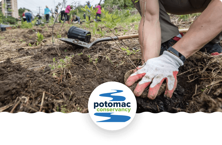
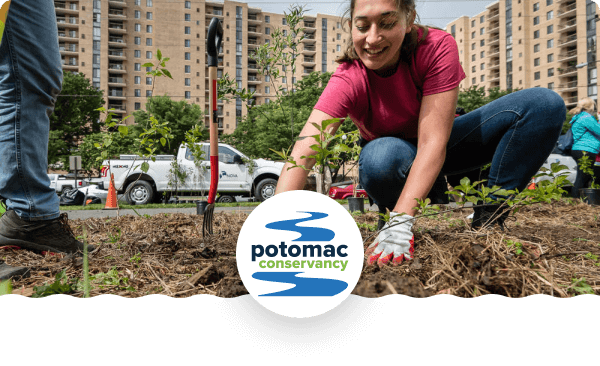
Harvesting Hope: Nature-based farming techniques that mitigate pollution
While large-scale, industrial agriculture is currently a major source of water pollution and greenhouse gas emissions, farming can be a major part of the solution if we embrace agricultural systems and practices that work with nature instead of against it.
Regenerative agriculture embraces farming strategies that regenerate natural systems to improve soil health, capture carbon naturally, and improve water quality.
Practice no till farming to prevent topsoil loss and reduce greenhouse gas emissions
Grow food forests and streamside trees to provide shade and protect water quality
Plant perennials and cover crops to protect and improve soil health
Use rotational crops and grazing to restore soil health and reduce pest infestations
Compost animal manure before applying to fields as fertilizer
Install bioswales to slow down and capture runoff
Transforming the agricultural system in our region is not only good for the planet, it’s good for crop yields and beneficial for the health of our communities and families. Regenerative agriculture does away with the need for fossil-fuel based synthetic fertilizers and pesticides, and it supports animals and crops in a mutually beneficial system rather than the inhumane operations of CAFOs.
River-friendly land management on Sunny Acres Farm
For John Venskoske, thoughtful conservation has always been a part of the ethos at Sunny Acres, his cattle farm in Frederick County, Virginia. The best management practices (BMPs) his family have placed on the property have evolved over time, making the land healthier for his cows and for Back Creek, an upstream tributary of the Potomac River that runs through the farm.
Two concerns of mine are clean water forever and a place to grow our food.
John Venskoske Cattle farmer in Frederick County, Virginia
“In 1947, we moved down here from Wheeling, West Virginia,” recalled Venskoske. “We had sheep, cattle, pigs, chickens – everything, you know – milk cows and beef cows. My dad was very conservation enthused, so we had a lot of ditching done.” Drainage ditches help filter polluted runoff and provide an alternative water source for livestock, so they don’t trample through nearby streams and pollute them with sediment and waste.
In the years since, John’s taken additional measures to protect Back Creek by installing streamside fencing, planting vegetation buffers, and adding a new water system for his livestock. In 2014, he worked with Potomac Conservancy to place a conservation easement on the property, a legally-binding action that permanently protects the farm’s lands, waters, and forest from development.
As part of the easement, John committed to creating a 35-foot forested buffer along Back Creek. “And then, in this buffer along the creek, we planted trees,” John said adding, “Oh, I don’t know, we did like four-hundred-and-some trees around the one pond that I fenced off, and the creek.” The mix of indigenous, hardwood trees along 6,150-feet of stream bank prevent soil erosion, capture carbon, provide shaded habitat, and protect Back Creek from polluted runoff.
John’s family installed fencing to prevent cattle from accessing and damaging the stream bank.
A forest buffer along Back Creek helps cool the stream, prevent erosion, and filter polluted runoff.
Resilient farming at Full Cellar Farm
Located about an hour’s drive from Washington, DC, Full Cellar Farm in Jefferson, Maryland is dedicated to a style of farming which cares for both the land and the larger community.
Since 2011, owners Kip and Sarah Kelley have been transitioning 30 acres of hilly land from conventional commodity crops to a diversified, sustainable operation that is more resilient to climate change. Together with their farm hands, Jimmy, James and Joe, they grow 20 acres of vegetables, 4 acres of hay, and 6 acres of chickens, turkey, and pigs in an integrated fashion.
Our farm is really a place rather than just a property.
Kip Kelley Owner of Full Cellar Farm in Jefferson, Maryland.
The Kelley’s transition to agroecological growing has helped them realize their dreams of growing nutritious, chemical-free food for their community in a way that protects healthy soils, water, and animals.
Agroecology incorporates elements of traditional ecological knowledge (TEK) and modern regenerative agriculture to provide a sustainable method for producing resilient farming systems.
In place of synthetic or chemical fertilizers, pesticides, or herbicides, the Kelleys utilize cover crops to prevent erosion and topsoil loss, crop rotation to keep soil productivity high, and compost or composted chicken manure to fertilize fields. The Kelleys have also installed drip irrigation to use water efficiently, and plants that attract pollinators are grown in vegetable rows.
In the 1980s, agroecology emerged as part of a rural social movement for food sovereignty, originating with peasant and indigenous agriculture in Latin America. According to master’s research by Emmalee Aman and Jamie Pratt, these movements grew in the 1990s, “building networks of farmers devoted to changing the social, political, cultural, and economic contexts that currently foster the growth of industrial agriculture and corporate control of food production.”
Balanced design with Ecologia
If you’re using chemicals, you’re lacking good design.”
Michael Judd Founder of Ecologia Design in Frederick County Maryland
Can you imagine a world without synthetic fertilizers or pesticides?
In their 2014 research, Emmalee Aman and Jamie Pratt confirmed that in the US alone, 324 million kg of 600 types of pesticides are used annually, causing environmental and social costs reaching about $8 billion each year.
That’s why Michael Judd founded Ecologia Design in Frederick County Maryland, an organization dedicated to bringing edible and ecological landscapes to our region through the principles of permaculture.
“It’s just diversifying and really working with the plants to bring in the balance that’s needed,” Michael explained, “so there’s no reason for herbicides. There’s no reason for pesticides.” He helps individuals and homeowners’ associations transform yards into functional, beautiful, edible whole-systems that are patterned after natural systems and targeted toward site-specific landscape needs.
Michael tailors what he’s learned from traditional ecological knowledge (TEK) and permaculture to fit the ecology of the Potomac River watershed. He cites the Lacandon Mayan tribe and Earthaven Ecovillage in North Carolina as important leaders and personal mentors in the design of balanced systems.
“After living with the Lacandon, I got to see how they interacted with the forest, and how they harvested their foods, their medicines, their fibers, you know, just how they integrated their lives by living with this dynamic perennial system. And it blew my mind to see that we, as humans, as a species, can do this,” Michael said.
Examples of permaculture design include:
Food-producing perennial plants that grow well naturally in our region are largely self-sufficient and don’t require fossil-fuel based chemical fertilizers or pesticides. Pawpaw trees, persimmon trees, elderberry bushes, and blackberry bushes are great local fruit-producers while black walnut and hickory trees provide plentiful nuts.
Food forests are a method of growing food like the forest, with seven layers of food and medicine producing trees, shrubs, herbs, groundcovers, mushrooms, root crops, and climbers, as well as system plants that fix nitrogen, produce mulch, and increase pollination. Food forests function as an ecosystem, producing the same benefits as other types of forests while also producing food for people and wildlife.
Water-focused designs help to hold more moisture in the soil rather than allowing precipitation to runoff. Bioswales, terracing, and rain gardens build healthy soil and increase organic matter, which then sequesters more carbon from the atmosphere.
Tell Congress
Our future is bright! The climate crisis is the challenge of our lifetime – but we have the power to overcome it.
Congress is moving quickly to pass a budget reconciliation package. This package is a once-in-a-generation opportunity to win major investments in addressing climate change. This $3.5 trillion climate and infrastructure bill could invest billions in helping farmers reduce greenhouse gas emissions, sequester carbon, and adapt to a changing climate.
Right now, the House and Senate Ag Committees are deciding how to spend $135 billion for agriculture. We must ensure that their solutions are equitable and work for young and Black, Indigenous, and people of color (BIPOC) farmers.
To build a food system that is resilient enough to feed us in a changing climate, we must dramatically increase public investments in sustainable farming and farming communities – including those who have been, and continue to be, underserved by U.S. farm policy.
Write to your federal legislators right now to ask for:
$30B for conservation programs
$5B for sustainable and organic agriculture
$3B to support development of resilient infrastructure in rural areas
$10B for debt relief to under-resourced farmers
Fund the creation of a Civilian Conservation Corps to provide early-agricultural career training in paid land stewardship
Take action right now to save a local forest!
TELL CONGRESS:
support climate solutions and equity in agriculture!
Help prepare our farms for the future! Tell Congress to pass critical funding for conservation practices, sustainable farming, and agricultural career training to make our farmland more productive and climate-friendly!
Potomac Conservancy is rolling out a six-part series to uncover the rich and complicated nature of the climate crisis in our region. Don't miss out! Sign up for e-alerts and we’ll let you know when our next "Rising to the Challenge" story is out.
Fun fact: Scientists can identify increases in atmospheric carbon dioxide are, indeed, human-made because carbon created by burning fossil fuels has a different isotopic ratio of heavy-to-light carbon atoms than carbon produced naturally by living plants.
Fun fact: While carbon dioxide is the main culprit, other gasses like methane and nitrous oxide also add to the atmospheric soup of heat-trapping greenhouse gasses. Methane is released from natural gas fracking, the decay of organic waste put in landfills rather than composted, and from livestock and industrial agricultural practices. Nitrous oxide is released during fuel combustion and during the application of fossil-fuel based fertilizers or un-composted manure to fields (U.S. Environmental Protection Agency, 2020a).
In 2015, the ATMOS Research and Consulting for Kleinfelder published local climate projections by studying historic emission and temperature data at three District sites: Dalecaria Reservoir, the National Arboretum, and Washington National Airport.
Andrew Elmore co-authored a study on the warming waters of the Chesapeake Bay for the University of Maryland Center for Environmental Science.
Fun fact: Scientists can use high resolution climate models to tell whether an extreme event was made more likely by climate change – whether it served as a key ingredient in the storm’s formation. This is called “extreme event attribution.”
Fun fact: A rainfall event that is so heavy and unordinary that it only statistically happens once every 100 years
The National Weather Service confirmed an EF0 tornado touched down in Washington, DC and an EF1 tornado touched down Arlington, VA on Thursday, July 1, 2021. The nation’s capital has only experienced three confirmed tornadoes above an EF0 level in the last fifty years (two of which occurred on the same day in 2001).
FACT: According to the U.S. Geological Survey (USGS), glaciers and ice sheets store enough water to raise sea level by about 68 to 70 meters (223 to 230 feet) (Cronin, n.d.).
Thermal expansion is the phenomenon whereby the upper layer of the ocean absorbs heat from the warming atmosphere and expands
Over 400 miles in length, the Potomac River flows with fresh water from the highlands of West Virginia downstream to Washington, DC where it mixes with brackish saltwater and continues on to the Chesapeake Bay, the largest estuary in the world. The Potomac experiences daily low and high tides as far upstream as Washington, DC.
One such effort is underway in Washington, DC where tunnels are being constructed underneath the city’s rivers to divert excess rainwater and reduce sewer overflows into local streams. As part of the $2.7 billion Clean Rivers Project, DC Water has built a 5-mile long tunnel under the Anacostia River with plans to start building another one under the Potomac River in 2023. The plan also includes investments in tree plantings, rain gardens, and other types of nature-based infrastructure.
Living shorelines are a type of nature-based infrastructure that incorporates indigenous vegetation, either alone or in combination with harder materials for structure and stabilization. They restore ecosystems that naturally withstand and recover from the flooding that has become more common because of rising seas, stronger storms and heavier precipitation. Further, living shorelines build habitats that sequester, or store, carbon. According to NOAA, “one square mile of saltwater marsh stores the carbon equivalent of 76,000 gallons of gas annually.
Extreme heat conditions are defined as weather that is much hotter than average for a particular time and place—and sometimes more humid, too.
The heat index is a measure of how hot it feels when relative humidity is factored in with the actual air temperature. Relative humidity is the percentage of moisture in the air compared with the maximum amount of moisture the air can hold. Humidity is an important factor in how hot it feels because when humidity is high, water doesn’t evaporate as easily, so it’s harder for your body to cool off by sweating.
Ozone (O3) is a highly reactive gas composed of three oxygen atoms. It is both a natural and a man-made product that occurs in the Earth's upper atmosphere
(the stratosphere) and lower atmosphere (the troposphere). Depending on where it is in the atmosphere, ozone affects life on Earth in either good or bad ways.
Stratospheric ozone is formed naturally through the interaction of solar ultraviolet (UV) radiation with molecular oxygen (O2). The "ozone layer," approximately 6 through 30 miles above the Earth's surface, reduces the amount of harmful UV radiation reaching the Earth's surface.
Tropospheric or ground-level ozone – what we breathe – is formed primarily from photochemical reactions between two major classes of air pollutants, volatile organic compounds (VOC) and nitrogen oxides (NOx). These reactions have traditionally been viewed as depending upon the presence of heat and sunlight, resulting in higher ambient ozone concentrations in summer months.
Ground level ozone is a secondary byproduct of a chemical relation between human-made nitrogen oxides (NOx) and volatile organic compounds (VOCs) in the presence of sunlight. Humans are producing an extra 24 million tons of NOX annually through combustion processes from vehicles, power plants, cement factories (which are located adjacent to many communities of color in the Potomac River region), and other industry.
Nutrients—primarily nitrogen and phosphorus—are essential for the growth of all living organisms in aquatic ecosystems. However, excessive nitrogen and phosphorus degrade water quality.
Both nitrogen and phosphorus feed algal blooms that block sunlight to underwater grasses and suck up life supporting oxygen when they die and decompose. These resulting "dead zones" of low or no oxygen can stress and even kill fish and shellfish. Algal blooms can also trigger spikes in pH levels, stressing fish, and create conditions that spur the growth of parasites.
The incubation period is the number of days between when you're infected with something and when you might see symptoms. Health care professionals and government officials use this number to decide how long people need to stay away from others during an outbreak.
Coal ash, also referred to as coal combustion residuals or CCRs, is produced primarily from the burning of coal in coal-fired power plants.
Coal ash contains contaminants like mercury, cadmium and arsenic. Without proper management, these contaminants can pollute waterways, ground water, drinking water, and the air.
A Superfund site is an abandoned toxic waste site (usually that once supported an oil refinery or smelting or mining activities). In response to attention on sites like these in the late 1970s, Congress established the Comprehensive Environmental Response, Compensation and Liability Act (CERCLA) in 1980.
CERCLA is informally called Superfund. It allows EPA to clean up contaminated sites. It also forces the parties responsible for the contamination to either perform cleanups or reimburse the government for EPA-led cleanup work.
When there is no viable responsible party, Superfund gives EPA the funds and authority to clean up contaminated sites.
Frontline communities are those that experience “first and worst” the consequences of climate change. These are communities of color and low-income, whose neighborhoods will be increasingly vulnerable as our climate deteriorates.
Adaptive capacity is the ability of a habitat to support its species and ecosystem functioning as the climate changes. Plants and animals respond to changing climate by adapting, shifting their range, or fleeing completely.
Species that reproduce quickly are able to adapt or migrate more readily than slower growing, long-lived. species – like Maryland’s bald cypress that regularly lives up to 600 years.
Agriculture, development, and past logging operations played a large role in the large-scale loss of eastern hemlock throughout the Appalachian region.
Indigenous to East Asia, the fast-spreading hemlock woolly adelgid insect attaches to the soft, woody plant tissue and sucks nutrients from the sap of eastern hemlocks. Once the insect establishes a population on a hemlock, it can kill the tree within four years. Click on the link to read more about the pesky adelgid.
Coldwater streams make up approximately 2,750 miles of Maryland’s freshwater streams, spanning across Allegany, Garrett, Frederick, Carroll, Washington, Montgomery, and Prince George’s counties. In West Virginia, coldwater streams are found chiefly in the eastern panhandle. In Virginia, coldwater streams meander through the mountains and valleys of the Interstate 81 corridor, stretching across Augusta, Rockingham, Shenandoah, Warren, and Frederick counties up through Berkeley County in West Virginia.
Rainbow trout from the western U.S. and brown trout from Europe were introduced to the region in the late 1800s. They have slightly higher temperature tolerances and, once temperatures reach 68°F, they can out-compete indigenous brook trout. Elimination by competition is already occurring in some streams.
Fun fact: Salamanders are ectotherms, meaning they regulate their body temperatures through their environment. They sun themselves on rocks to warm up and cool off in streams or shaded areas.
Salamanders prefer temperatures between 33°F and 60°F. Their metabolism and heart rate slows when temperatures reach 50°F to survive more extreme conditions.
The opportunity to roam for resources is an important need for animals’ adaptive capacity in the fight against environmental changes.
NatureServe based its research on data from a weather station in Rock Creek Park and then used an ensemble of global climate models from the IPCC’s 5th Assessment Report to project near-future climate conditions in the Park.
In slightly salty oligohaline marshlands, salinity ranges from 0.5- 5 parts per thousand (ppt).
Visit Dyke Marsh or Mattawoman Creek to venture through two of our region’s freshwater marshes, areas of the Potomac River with salinity ranging from 0-0.5 parts per thousand (ppt).
According to a 2016 study in PLoS One, this edge might only be pushed up as far as Indian Head by the end of the century due to the region’s topography and the potential for water to spill out cross-sectionally (widening the river), rather than being pushed far upstream (Cadol et al., 2016).
Visit The American Scientist’s “Spring Budburst in a Changing Climate” for more information on how a warming climate is throwing off the timing of spring. The authors use Henry David Thoreau’s 160-year-old field notes to compare the timing of spring activities between then and now.
Roosevelt Island was transformed back into a “real forest” in the 1930s to mimic the natural ecosystems that covered the landscape before settler-colonial interference. Learn how this island has been transformed time and again – including how it was used as a place of refuge by people who were enslaved.
Source: University of Maryland Center for Environmental Science, 2015; Ding & Elmore, 2015.
www.umces.edu
The Maryland Commission on Climate Change, the Department of the Environment’s Scientific and Technical Working Group (STWG).
Every community produces polluted runoff – a type of pollution caused when excess rainwater carries toxins, debris, and litter into nearby streams – but the issue is particularly problematic on farmland. In fact, agricultural runoff is the greatest source of pollution to our region’s waterways. Poor land-use practices on farmland pollute streams with excess nutrients from fertilizers, pest treatments, and animal feces.
In 2018, the United States’ agricultural activity alone emitted approximately 698 million metric tons of greenhouse gasses into the atmosphere: 12.3% as carbon dioxide, 36.2% as methane, and 51% as nitrous oxide (U.S. Department of Agriculture, 2020).
Nitrous oxide is 298 times more potent than carbon dioxide over one hundred years, and is produced as microbes in the soil break down fossil-fuel based synthetic fertilizers and manure that hasn’t been aged or composted before being applied to fields.
Best management practices (BMPs) are conservation measures that improve land health and prevent or mitigate pollution through natural means. BMPs are critically important to restoring water quality in the Potomac River region. Potomac Conservancy helps connect area landowners to available resources to implement BMPs on residential properties with a focus on family-owned farms in the headwaters region.
Learn more at www.potomac.org/lands.
TEK refers to the ever-evolving wisdom gained by indigenous and locally rooted peoples over hundreds of years by means of direct contact with their environment. The U.S. Fish and Wildlife Service explains that, “this knowledge is specific to a location and includes the relationships between plants, animals, natural phenomena, landscapes, human beings, and timing of events that are used for lifeways,” like agriculture or hunting and trapping (Rinkevich et al., 2011).
Source (Aman & Pratt, 2014).
Industrial farming that relies on growing expansive fields of one crop – corn, wheat, soy, as examples – planted year after year, drain the soil of essential nutrients and lack the genetic diversity to fight diseases and pests. Consequently, they require the help of artificial additives.
The Lacandon are the last of the Mayans who escaped the Conquistadors’ forced Christianity by hiding in the heart of the jungle. For the last five hundred years, the Lacandon lived very simply and have kept their borders closed to outsiders. Their population consists of about six or seven hundred people now.
Earthaven Ecovillage is a permaculture community outside of Black Mountain, North Carolina that applies Traditional Ecological Knowledge.
Take action title
Plus a short introduction or description far far away, behind the word mountains, far from the countries Vokalia and Consonantia, there live the blind texts. Separated they live in Bookmarksgrove right at the coast of the Semantics.
Download the complete Potomac Conservancy 2021 Climate Report PDF
Plus a short introduction or description far far away, behind the word mountains, far from the countries Vokalia and Consonantia, there live the blind texts. Separated they live in Bookmarksgrove right at the coast of the Semantics.
Get updates for new chapters of the Potomac Conservancy 2021 Climate Report.
Plus a short introduction or description far far away, behind the word mountains, far from the countries Vokalia and Consonantia, there live the blind texts. Separated they live in Bookmarksgrove right at the coast of the Semantics.
Demand urgent climate solutions to protect clean water and healthy families!


 Published December 20, 2021


 Press/Media